More information on this image is available at the Easton Historical Society in North Easton, MA
www.flickr.com/photos/historicalimagesofeastonma/albums
The development by Oliver Ames and Sons Corporation of the factory and village land use in a rather organic manner with a mix work-related classes created an integrated geographic network. The housing on perimeter edge with factories and business affairs in the center creating the village concept in North Easton. Other important concepts were the Furnace Village Cemetery, Furnace Village Grammar School and the Furnace Village Store, which explains Furnace Village and other sections of Easton.
source: Massachusetts Historical Commission
.
Description of Unionville and Washington Street below
.
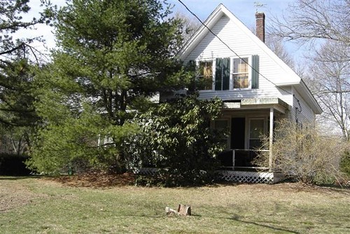
125 Washington Street
This house is historically known as the Lyman and Louisa Packard House. On April 18, 1846, records show Asphalt, a shoemaker, and Rhoda Wade, living at 117 Washington Street, sold 125 Washington Street to Lyman Packard. On April 9, 1848, Lyman and Louisa Packard were married in North Easton. Showing on the 1851 and the 1871 maps, living on the westerly side of the street, owners were Lyman, a shoemaker, and Louisa Packard with two daughters, Hannah S. and Elizabeth F. Packard. In the mid 1850’s and the ’60’s, owners were Lyman, a shoemaker, and Louisa Packard keeping house with two daughters, Hannah S. and Elizabeth F. Packard. On June, 12, 1860, Lyman, a shoemaker, and Louisa Packard, owners of 125 Washington Street, deeded a lot of land across the street on the east side of the street. The property, was formerly owned by E. Packard as shown on the 1852 map described as near the dwelling house of Lorenzo Smith to the inhabitants of School District No. 8 of Easton. The land was for a new school to replace the one built in 1860 on the same site as the older school. In the mid 1860’s, owners were Lyman, a shoemaker, and Louisa Packard, who was keeping house with three daughters, Hannah S., Elizabeth F. and Fidelia Packard. In the early 1880’s, owners were Lyman, a shoemaker, and Louisa Packard. On October 16. 1893, widowed Lyman Packard sold the property to Francis S. and Hattie Hayes. Lyman Packard died on April 6, 1898 with burial at the Washington Street Cemetery next to his wife, Louisa Packard, who passed away on June 23, 1882.
In the 1900s, owners were Francis S., a shoe factory leather sorter, and Hattie L. Hayes with Francis’ mother, Hannah Hayes, residing with the family. In the 1910’s, owners were Francis S., a shoe factory sorter, and Hattie L. Hayes. In the 1920’s, owners were Francis S., a shoe worker, and Hattie L. Hayes. In the 1930’s, owners were Francis S., a shoe factory sorter, and Hattie L. Hayes with a boarder, Charles W. Phelan residing at the house. Charles W, Phelan later moved to 121 Washington Street. In the early 1940’s, Francis S. Hayes received a Gold Sheaf certificate for fifty years of membership in the Easton Grange. On May 20, 1936, Francis S. and Hattie L. Hayes sold the house and attached property towards the south, to Guy Carl, a farmer at the chicken farm, and Ruth A. Carpenter with their son, Carl R. Carpenter. Easton had operator-assisted phone service in the late 1930’s and the ’40’s. Guy Carl and Jeannie Carpenter had the number of Easton 491 prior to the dial-direct service which came to Easton in 1957. During World War II, Guy Carl Carpenter, a well known toolmaker with some of his tools now in the archives of the Easton Historical Society, was employed by Crofoot Gear, a maker of parts for war planes, on Central Street in South Easton. In the 1940’s, owners were Guy Carl and Jeannie Carpenter. Guy Carl Carpenter was a custodian and crossing guard at the Unionville School. On September 9, 1948, owners Guy Carl, and Jeannie Carpenter sold the northern half of the long time parcel to Robert G., a service manager, and Mildred S. Carlin until the Carlins sold the property to Thomas A. and Ann H. Mann.
source:Easton Historical Society
source; Massachusetts Historical Commission
source: Ancestry
source: History of Easton, William L. Chaffin, 1886
source: Easton’s Neighborhoods, Edmund C. Hands, 1995
.
Unionville
Unionville, located in the northeast area of Easton, Massachusetts, consists of Main Street on the South and the Easton-Stoughton line on the North, Easton-Brockton line on the East and a few hundred yards west of Washington Street on Elm Street. Back in 1793, the northeast section of Easton was known as a district with a District Eight Schoolhouse between 164 and 166 Washington Street. Students in Stoughton near the town line attended the Unionville School until 1822 when the District built a new schoolhouse north of 120 Washington Street. Unionville got its name from the practice of students from near the line in Stoughton attending with monies from both towns. Over the years, Unionville has been referenced as being thrifty and given a name of the Other Neighborhood. In 1995, historian Edmund C. Hands explained in his book, Easton’s Neighborhoods, Unionville was nicknamed the “Dark Corner” because it lacked the new gaslights found in North Easton Village in the 1880s. The name of the Dickerman Neighborhood was based on a family moving in from Stoughton in the northern end of Unionville expanding their routes by marriage throughout the neighborhood including the name of a road in their name at the corner of the James and Joanna Dickerman House at 91 Washington Street. Square Top Neighborhood was the name given Unionville with the Square Top Church located at 195 Washington Street. Time and events shaped the activity in Unionville. In the 1700s and the early 1800s, the Dorchester Meadow Brook, French/Knapp’s Pond and Stone/Monte’s Pond were the initial business operative part of the District with ice houses, mines, forges and mills. In the late 1800s, and early 1900s, Washington Street becoming the major road which saw increased activity with the William A. Smith’s General Store, Square Top Church, the Washington Street Cemetery and the Easton Grange at the intersection at Elm Street. Later, the center of business activity drifted south from Washington at Elm Street to Dailey’s Corner with the opening of Ladd’s Gas Station, Yankee Hostess, Stonehill College, Hilliards House of Candy, Tastee Freeze and Fernandes Super Market.
source; Massachusetts Historical Commission
source: History of Easton, William L. Chaffin, 1886
source: Easton’s Neighborhoods, Edmund C. Hands, 1995
source: History of Unionville, Carl B. Holmander, 2014
.
Washington Street
In June, 1697, an initial layout took place for the Taunton and South Boston Turnpike which ran from the Stoughton town line through Unionville, into South Easton to the Raynham border. Before the survey in 1726, in the 1710’s, in the North Purchases records as the "road that leads from Joseph Crossman’s to Boston." Joseph Crossman lived near what later became known as Dailey’s Corner. In a survey that took place in 1726, the old road began a little west of the present road at the Stoughton line, crossed the new road on the hill by the Dickerman’s property and stayed a little east of the new road past the Washington Street and Timothy Marshall’s house a little way south to take the bend to avoid the swamp south of Timothy’s place. In 1803, the Stoughton Turnpike Association petitioned the state’s General Court for a (Washington Street) road contrary to other suggested paths. In 1805, the General Court sent a Committee to view the proposals for different routes. In 1807, the Committee, as directed by the General Court laid the chosen road (Washington Street). The route, South Boston and Taunton Turnpike, aka, Taunton and South Boston Turnpike, went from Taunton Green to the so called Blue Hill Turnpike, which was completed in 1809. Showing on the 1852, 1855 and the 1871 maps, the new turnpike divided the travel between Boston and Taunton with the older road, called Bay Road in the northern end of Easton. In 1898, the Taunton and South Boston Turnpike, which included Stoughton at the time, was named as a state road. Showing the street on the 331895 map, in 1900, the Easton Street Railway was organized to construct a street car line that ran through Unionville. In the Volume 2 of History of the Town of Easton, Margaret McEntee and other historians, wrote on page 52 about the Easton Street Railway, starting in 1903, ran street cars from Stoughton Square through Unionville to Morse’s Corner on tracks in the middle of Washington Street. The line took on a nickname "Joy Line" because it looked like the conductor and driver were having fun because of the low ridership that made them feel like going for a ride. The line did not operate in the winter. The line was taken over by the Bristol and Norfolk Street Railway. The merger was not enough to save the Easton line which ceased operations in 1904. In the 1920’s, the turnpike getting known as Washington Street in Unionville was given the designation by the State of Route 138. It became the first two-lane concrete constructed highway in Easton. In 1947, the State announced plans to take the traffic off Route 138, to be known as Route 24, along with Route 138, are both built parallel to an old Indian trail. In 1958, the relocated Route 138 portion of Route 24 was opened alleviating traffic through Unionville at the time. On a geographical note, Washington Street is the high point line dividing the water sheds of the Queset Brook on the western side and the Dorchester Meadow Brook, running parallel between Washington Street and the Brockton line.
source: History of Unionville, Carl B. Holmander, 2014
Washington Street
Washington Street is referred to in 1719 in the North Purchase records as the Rhode that leads from Joseph Crossman’s to Boston,Joseph Crossman then living at what is now Thomas Randall’s place, on Main Street near Washington Street, in North Easton village. But that part of the street which ran through South Easton village is alluded to before 1700. The first recorded laying out of any part of it is dated September 30, 1726, when it was laid out from just below the South Easton cemetery to the Green. June 18, 1728, it was laid out from the Stoughton line to Joseph Grossman’s ; and March 25, 1737, the survey was continued to South Easton, where the survey of September, 1726, began. The old road was quite different from the present, and may be traced most of the way at least throughout District No. 8. It began fifteen rods west of the present road at the Stoughton line, crossed the new road diagonally on the hill where the Dickermans live, kept slightly east of the new road until some distance south of Timothy Marshall’s, then crossed the road southwesterly to avoid the swamp, going to the west of it, and then, as may be still clearly seen, passed nearly due south, coming out into the present road just in front of the Nathan Willis place. South of this the divergence was less than above. The extension of Washington Street southward from the Green was made in 1807. The Stoughton Turnpike Association had then been formed, having been petitioned for as early as 1803. There had been a great wrangle on this question of turnpikes. The General Court in 1805 sent out a committee to view the several routes proposed. The town was not in a pleasant mood. It voted that it wanted a turnpike, but not by the Bay road, nor by the Stoughton road (Washington Street), nor by " Gilmore’s rout (so called)." The town was however overruled, and not only was the turnpike by Gilmore’s rout (so called) allowed, but the Stoughton route was also allowed. The Stoughton Turnpike Association was formed, and on pettion to the Court of Sessions at Taunton a committee, consisting of the Hon. Stephen Bullock of Rehoboth, Samuel Tobey, Esq., of Berkley, James Williams and James Tisdale of Taunton, and John Pool of Easton, was appointed, and proceeded to lay out a road four rods wide as the law directs. This was done September, 1807. The divergence from the old road has been indicated above, and the survey was most carefully made. Some of the older residents of Easton will be interested in knowing who the then landowners were, in their order from the Stoughton line to the intersection with the Taunton and South Bridgewater Turnpike. They were Joseph Morse, Ebenezer Dickerman, James Dickerman, Joseph Drake, Widow Drake, Elijah Smith, Ephraim Willis, Jonathan Leonard, Ebenezer Randall, Hopestill Randall, Esquire Guild, Dr. Seth Pratt, Esquire Guild, Thomas Willis, Widow Pratt’s improvement to the well of water and Sever Pratt by’ the burying-place Calvin Howard, Abial Mitchell, part on the old road, and Lyman Wheelock ; and on the old road, Barney Randall, Bela Reed, Esquire Guild, Phineas Randall, and Daniel Randall; same course eight rods on the old road to the Green, James Guild, James Willis, Daniel Randall, Edward Howard or Hayward. Israel Alger, Isaac Lothrop, John Lothrop, Asa Howard, Roland Howard, ending at the Boston and Bristol Turnpike. There was no turnpike gate on this road in Easton, but there was one in Stoughton. The part of the old road south of the Methodist meeting-house to its intersection with the turnpike was discontinued in 1809, that south of this place to the Nathan Willis place in 18 12, and that from the Stoughton line to the turnpike in 1815.
source: History of Easton, William L. Chaffin, 1886